Today’s visual simulators are amazingly powerful systems for safely training individuals in a variety of virtual environments, such as sea, land and air. Originating a century ago, they progressed from mechanical motion controls and backdrops to dynamic systems providing the pilot essential visual cues.
Synthetic out-the-window views evolved to photorealistic, immersive worlds rendered by modern image generators -- visually striking databases using geospatial imagery and other real-world data. Advances in digital photogrammetry and image processing has led to today’s state-of-the-art geospatial production systems to create accurate foundation layers for image generators and other applications.
L3Harris, along with our customers and partners, have been a part of these developments along the way. Our geospatial solutions, serving government and commercial industries for decades, support crucial mission and business needs. Our TrueTerrain™ product line meets their wide-ranging and exacting requirements.
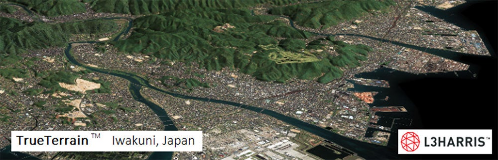
TrueTerrain 30cm imagery & correlated 8m DTM products, used in various applications, such as Simulation Image Generator database
TrueTerrain is a flexible, multi-layer solution including correlated imagery, elevation, vectors, 3D models, material classification maps, and FGDC-compliant heritage metadata -- available individually or bundled. TrueTerrain takes care of many technical details of which a few are illustrated below:
How can cohesiveness be achieved when multiple source images have different characteristics?
TrueTerrain ortho mosaics are created from multi-sensor, multi-resolution imagery using advanced in-house processing including automated registration and triangulation (using geometry such as RPCs, and sensor models), ortho-rectification, pan-sharpening, atmospheric correction, tonal balancing and cloud-removal to achieve a product recognized for its seamless, natural color.
How are needs for more accurate terrain, or specific digital elevation requirements handled?
TrueTerrain mosaics can utilize customer provided elevation or custom-built terrain and surface models. Advanced in-house algorithms and workflows rapidly create one-post-per-pixel, high-resolution and quality Areas of Interest (AOIs), spanning city blocks to continents. 3D urban models use commercial imagery for accuracy and stunning detail.
What if my databases require vector products such as roads or building footprints?
TrueTerrain vector products are built from imagery. Layers include linear networks such as roads, rail lines, runways, buildings, coasts and cultural boundaries. VMAP level 1 & 2 and AMDB ICAO products meeting military and commercial specifications are available. Accuracy and level of detail can be selected based on requirements.
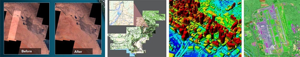
Left-to-right: 1) Before/After seamless processing. 2) Vector Layers. 3) Elevation Digital Surface Model. 4) Material Maps
Can multi-spectral image sources be used? What about material properties?
TrueTerrain nBand ortho mosaics utilize additional spectral bands dependent upon source. TrueTerrain material classification maps use all available bands. For each pixel, the two dominant materials and relative abundance of each material is determined. They are ideal for image generator sensor views, night vision, IR, radar visual databases, and mapping geotypical textures.
Advanced Geospatial Production and Partnerships
L3Harris' highly advanced Geospatial Product Generation System (GPGS) leverages over 60 patents and more than three decades of image processing expertise. State-of-the-art algorithms developed by image scientists and engineers automate product generation with high quality and accuracy.
The massive computing power of a scalable grid computing system is harnessed to process in minutes or hours, what could otherwise take many hours or days. Thousands of nodes and computing cores, and dozens of terabytes (TB) of RAM, makes large-scale production once previously unfeasible, now fast, practical and readily accessible.
L3Harris values the professional associations fostered over many decades in the VisSim industry, including an important, twenty-year partnership with Aechelon Technology:
“Aechelon Technology requires reliable geospatial sources to feed large scale multi-spectral products into our peta-byte scale processing center serving global geo-specific databases and devices employed in pilot, sensor and weapon training, mission rehearsal, command & control, Intelligence, Surveillance and Reconnaissance and ground stations for the US government, US allied forces and government prime contractors."
"Throughout Aechelon's twenty-one-year history, our company has maintained an unparalleled track record in program deliveries for the US Marine Corps, US Navy, US Air Force, US Army, Special Operations Command, US Government Foreign Military Sales Program and the US Coast Guard, thanks in part for relying on geospatial multi-spectral L3Harris data products."
L3Harris TrueTerrain Delivering Proven Solutions
L3Harris’ geospatial team of experienced analysts offers complete end-to-end service. For decades, this right-sized team has delivered the right product at the right time for the right value. Global partnerships with many satellite and aerial data suppliers, a vast archive, and flexible licensing specifically for VisSim allows us to meet or exceed customer cost, coverage, schedule and quality constraints. The TrueTerrain™ product line’s proven solutions continue to evolve with enhancements and new products to meet the needs of our customers and partners. To learn more, contact us today at GeospatialData@L3Harris.com.
"Because of the scale of our productions and our ever-increasing needs for higher ground truth, we partner continuously with L3Harris to serve our needs." - Javier Castellar Co-Founder & Vice-President of Programs for Aechelon Technology