Sorry, you need to enable JavaScript to visit this website.
Skip to main content

Synthetic Labeled Data

Understanding Mission Needs

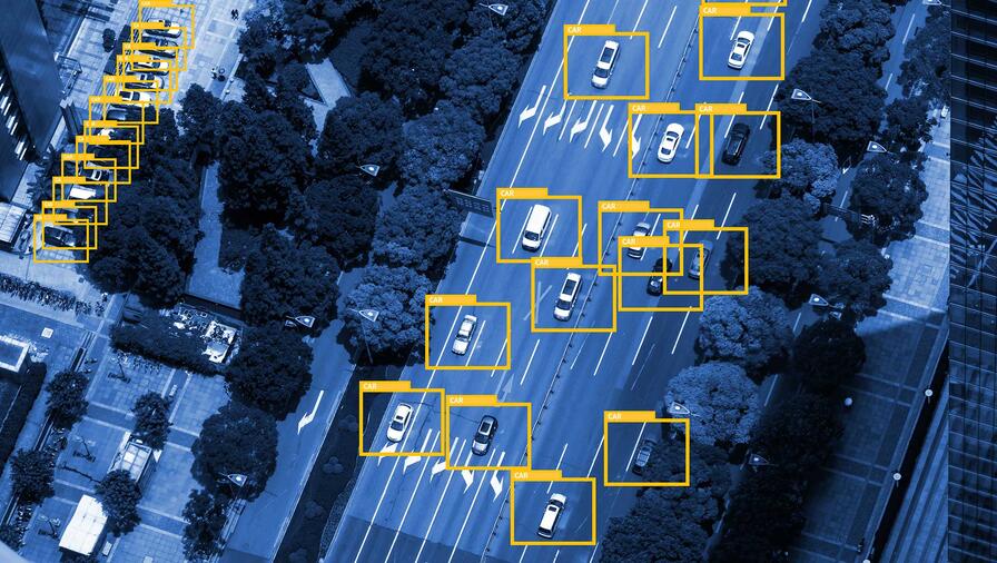
Agencies are unable to process new imagery as even newer data comes in. Artificial intelligence (AI) technology may offer a solution, but requires robust machine learning algorithms and industry-specific training datasets.

Where most commercial applications can take advantage of plentiful training data that is gathered through crowd-sourcing means, the intelligence and defense communities’ targets are often elusive. The means for gathering training data often require additional security considerations.

Validated Training Data

To support defense and intelligence machine-learning missions and reduce this training data burden, L3Harris is providing a trusted source of labeled synthetic training data to feed algorithms.

Our automated, defense-specific, synthesized, metadata-labeled datasets fill the training gap. This enables further development of deep-learning algorithms unhindered by lack of training data.

Enabling Artificial Intelligence

Technologies and knowledge gained from our 40-year legacy of delivering radiometrically correct, high-fidelity remote-sensing simulations yield proven synthetic training data for intelligence, surveillance and reconnaissance focused machine learning.

Today, using proprietary image sensor simulation and modeling techniques, L3Harris can automate simulated training data generation for defense-focused objects and systems of interest. L3Harris can provide training data production services or support the integration of custom synthetic data generation tools within customer workflows. These capabilities can support panchromatic, multispectral, thermal, hyperspectral and synthetic aperture radar (SAR) systems.

Radiometric Ray Tracing

There is a significant difference between synthetic data generated using a game engine and data generated by accurately modeling an imaging system end to end. While the gaming industry makes scenes look realistic to a human observer, they are not concerned with phenomenology the human eye cannot perceive (e.g. IR, HSI, SAR) or in simulating actual sensor characteristics under specific real-world collection conditions. L3Harris has led decades of corporate and government investment into the development of automated scene building capabilities that can support physics-based end-to-end modeling of remote sensing systems.

Sensor Modeling

L3Harris has 50-plus years of experience applying image-science expertise to imaging systems. Our modeling capabilities have supported airborne and space systems and a variety of government and commercial customers. L3Harris’ unique experience analyzing operational imagery for systems has fueled the development of models to accurately represent these systems within simulation environments. L3Harris has proven experience with all types of imaging systems, industry-leading image analysis, gold-standard modeling capabilities and operationally validated tools.

Domain Adaptation

Concerns regarding bias and bridging the synthetic-real gap have been central to our investments in synthetic data. L3Harris has invested in the use of domain adaptation to map synthetic data into the space of real data. It is essential to know how to map the synthetic data to the domain of the real data when training deep-learning models. L3Harris is ideally positioned to do this work with significant expertise in both synthetic data generation and deep learning neural networks. By using state-of-the-art metrics to characterize the relationship between synthetic and real datasets, L3Harris can manipulate the synthetic generation process to close the domain gap and thereby improve performance.

Synthetic Labeled Data Resources

  • L3Harris Synthetic Labeled Data Sell Sheet

    Synthetic Labeled Data Sell Sheet

  • Distributed, All-source Geospatial Analytics Resource for Hydra Spec Sheet

    Distributed, All-source Geospatial Analytics Resource for Hydra

  • L3Harris IntelliEarth Integrator Sell Sheet

    IntelliEarth Integrator Sell Sheet

Distributed, All-source Geospatial Analytics Resource for Hydra

Browser-based application provides multi-source geospatial intelligence faster using Hydra software architecture.

L3Harris’ distributed, all-source geospatial analytics resource (DAGR) modernizes the analyst workforce with automated multi-intelligence (multi-INT) workflows and workspace collaboration to solve complex intelligence questions.

Features

Features  HYDRA DAGR
Geospatial context for all multi-INT data objects   Standard
Machine-learning mode for labeled data creation and adjudication of detections   Standard
Single cohesive app experience to search, visualize products, use data layers, collaborate and invoke analytic capabilities   Standard
Private, personalized and enterprise dashboards that support data tagging, blogging and collaboration Standard Enhanced
Federated search and discovery capability Standard Enhanced
OGC (WFS) interfaces to support search and discovery Standard Enhanced
Algorithm governance and tracking Standard  
Algorithm recommendation services (image-based) Standard Enhanced
Ability to send products to external systems/services Standard Enhanced
Support algorithm invocation based on metadata interrogation (beyond file type) Standard Enhanced
Support for multiple algorithm containers (Docker, GSF and DeepCore) Standard  
Support for distributed processing (hosting algorithms on a remote server/cluster with a shared file system) Standard  
PKI/GeoAxis enabled with role and permissions-based visibility Standard Enhanced

With DAGR, the Hydra user searches, discovers, collaborates and invokes processing algorithms through a single cohesive application experience. Most tasks can be accomplished in a single workspace. DAGR’s map-based search and visualization capability provides geospatial context for all multi-INT data objects and enables users to save and retrieve their searches. DAGR also allows users to personalize their Hydra experience by creating  customized dashboards — easily accessible from anywhere in the enterprise system — that display actionable information about products, workflows, algorithms, reports and more. Desired analytic capabilities are exposed via recommended processing services.

About Hydra

L3Harris designed, developed, and — since 2007 — has updated and operationally delivered the Hydra software framework to address the U.S. government’s full-spectrum content and workflow management needs. With a service-oriented architecture built to open standards, Hydra is reusable and facilitates a wide variety of missions and use cases. It is scalable for adjacent mission focus areas and for multi-INT data integration and fusion. It can leverage a variety of virtualized environments, such as Amazon GovCloud or static virtual machines, to support collaboration across an enterprise. Because it is sensor neutral, Hydra can easily adapt to future data types and mission objectives.

Contact the Geospatial Team

Address
Reason for inquiry *

Related Domains & Industries

Solutions that solve our customers' toughest challenges.
view all capabilities