As noted in Part 1 of this blog series, DEMs are typically created from remote collection of data from optical imaging sensors (aerial or satellite platforms), LiDAR scanners, or IFSAR mapping systems. There are two types of DEMs – Digital Terrain Models, or DTMs, that have been stripped of vegetation and structures and represent the ground only elevation, and Digital Surface Models, or DSM, which include all elevations including open ground, vegetation and buildings/structures.
Here are common DEM applications and suitable products:
Civil Engineering
For pre-planning projects that require cut-and-fill volumetric calculations to move dirt for construction of roads or railroads, large area drainage studies, and long corridor route selection for pipelines, fiber optic, or telecom planning, medium- or high-resolution DTMs are effective. Off-the-shelf DTMs favored for engineering include the Airbus WorldDEM, which offers 4 m vertical accuracy on a 12 m grid cell spacing acquired by German TerraSAR-X and Tandem-X satellites since 2011. Another option is the AW3D product derived from Japanese ALOS optical satellite data, yielding 7 m vertical accuracy on a 5 m grid cell. Intermap airborne IFSAR data with 5 m cell size and 1 m vertical accuracy from 2003-2012 is also available for many parts of the world.
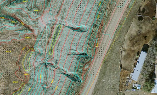
Example of a very detailed DTM with 1.0 ft. interval contours and 0.25 ft. pixel orthorectified image.
And because engineers work in CAD software environments, they prefer DTMs in simple vector formats derived using either photogrammetric techniques from stereo aerial optical images or airborne LiDAR mapping. Engineering projects related to development in urban and suburban environments often require a DTM and as-built features, including building footprints, curb lines, roadways, and fence lines. These features are best extracted photogrammetrically from optical air photos, a service provided by Harris.
GIS Mapping
For nearly any type of large GIS mapping project related to land use, transportation, urban and emergency planning and natural resource management, Harris operates an airborne Geiger-Mode LiDAR system that offers a unique combination of high point density of up to 20 points per meter (ppm) over broad areas. Many DTM/DSM data sets are available off the shelf, while custom feature extraction is also offered.
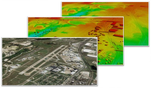
DSM, DTM, and ortho image derived from high-resolution stereo satellite image data.
Hydrological Modeling
Mapping flood plains has become critical in areas along rivers and near coasts. DTMs are most commonly used in these applications, which are often regional and require coarse or medium grid data. Depending on budget and scale, the most popular products are the Airbus WorldDEM and the free SRTM DEM products. Additionally, USGS offers free hydrologically enforced DTMs at 30 m, 10 m and 3 m resolutions. The Restec / NTT Data AW3D Enhanced MultiView photogrammetric derived DEM products are also emerging as useful where high accuracy is required in remote areas of the world.
3D Visualization
Creation of photo-realistic topographies is done routinely by military organizations for mission planning and flight simulation/training systems. These immersive environments are usually built by draping an optical image over a DSM so that land cover and surface features, whether natural or man-made, are displayed accurately in 3D.
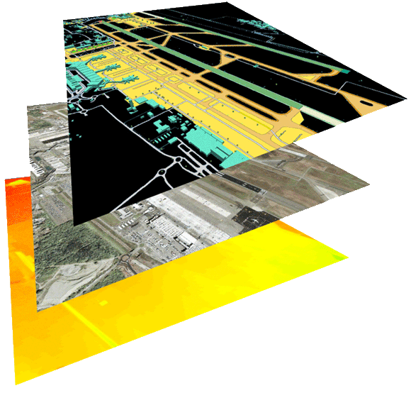
Aerodrome Mapping Database developed by Harris.
Coarse-resolution DSMs are usually sufficient for regional-sized applications, and popular products are the 30- and 90-meter DEMs acquired in the 1990s by the U.S. Shuttle Radar Topography Mission (SRTM). Available at no cost, SRTM data has become dated, however, updated and enhanced versions have been developed by commercial companies in the U.S. and Japan.
Flight simulation around airports requires at least a moderate or high-resolution DSM product, and Harris has assembled a database of airport DEMs. Mostly extracted photogrammetrically from stereo-optical satellite images, these data sets accurately display buildings and vertical features on and around airports.
Geohazard and Subsidence Monitoring
For continued monitoring of ground movement related to seismic activity or hydrocarbon production, high-resolution SAR data is extremely efficient. Harris offers a cost-effective SARscape monitoring service that uses SAR data from the European Sentinel-1 satellite.
Telecommunications
Designing cellular telecommunications networks requires line-of-sight mapping with DSMs that show all vertical obstructions in the landscape. Accuracy and resolution are both important in designing the new 5G network, and Restec / NTT Data AW3D Enhanced DEMs are the popular for this endeavor. In rural areas where obstacle location accuracy is not critical, the Airbus WorldDEM products are sufficient.
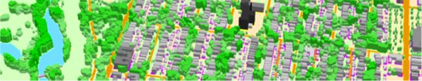
3D Clutter / Land Cover map for radio propagation simulation, Courtesy NTT/Restec.
Utility Infrastructure Monitoring
Custom collection of LiDAR by airplane, helicopter or drone is performed on regular schedules by many utilities to assess the condition of their electric transmission and distribution facilities. For relatively small corridors, drones are gaining in popularity due to their cost effectiveness. Although Harris does not conduct UAV surveys, we do offer OneButton software and DEM mapping/editing services.

