Space-based Missile Warning & Defense

The Emerging Threat: Hypersonic Missiles

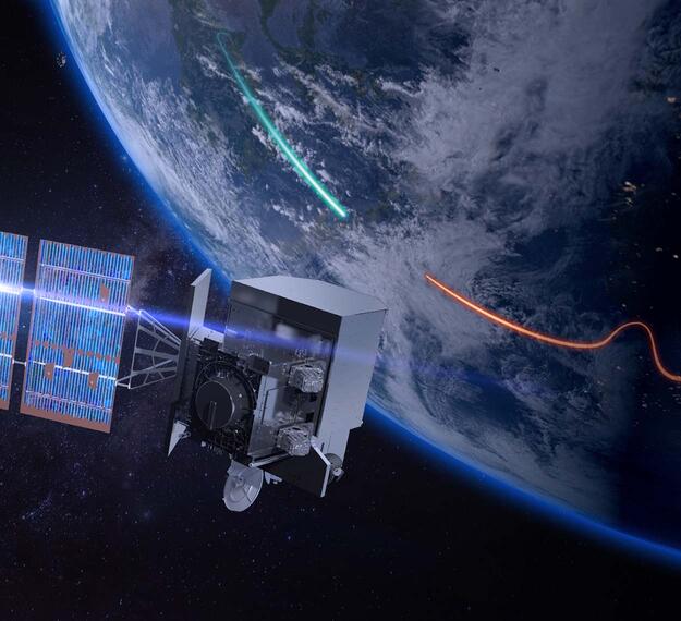
As global threats increase, so have our adversaries’ missile capabilities. A new generation of missiles has taken center stage: hypersonic glide vehicles. These weapons are not only faster and more maneuverable than traditional ballistic missiles, but they're also incredibly difficult to track. Because of the faint heat signature and unpredictable flight trajectory of hypersonic missiles, the only way to identify and track them is with advanced satellite technology.

To stay ahead of this emerging threat, the U.S. military is building a robust constellation of missile warning and defense satellites across the following orbits: geosynchronous orbit (GEO), highly elliptical orbit (HEO), medium-Earth orbit (MEO) and low-Earth orbit (LEO). This multilayer architecture is designed to quickly detect, accurately track and precisely target threats — most notably hypersonic vehicles that elude traditional defense architectures. 

We're leveraging our extensive 60-year history designing, building and testing mission-critical infrared instruments in both GEO and LEO to add vital capabilities to the U.S. military’s multilayered approach to missile warning and defense. These contributions will help keep our nation ahead of advanced, rapidly evolving threats like hypersonic missiles.
L3Harris' Role: Answering the Call to Defend Against Advanced Missile Threats

We’re answering the call to detect, identify and track advanced hypersonic missiles using multilayered, digitally engineered missile defense solutions. Our solutions provide immediate and continuous global coverage of threats using highly sensitive instruments that detect both dim and bright targets. This technology, equipped with real-time onboard processing, can follow hypersonic missiles at different geometries and atmospheric conditions.

L3Harris’ mission-defining technology is playing a critical role on several missile warning and defense satellite programs, including:

  • The Missile Defense Agency's (MDA) Hypersonic and Ballistic Tracking Space Sensor (HBTSS) Program
  • Tranche 0 (T0), Tranche 1 (T1) and Tranche 2 (T2) of the Tracking Layer for the Space Development Agency's (SDA) Proliferated Warfighter Space Architecture (PWSA) Program
  • The U.S. Space Force’s (USSF) Wide Field of View (WFOV) Missile Warning Sensor
  • The USSF Space Systems Command’s (SSC) Medium Earth orbit (MEO) Missile Track Custody (MTC) Epoch 1 Program 

Responsive, Rapid & Resilient Solutions

Threats to space-based missile warning and defense assets are growing by the day. In addition to rogue satellites and space debris, directed physical attacks and cyberattacks highlight the emerging risks the U.S. military must be prepared to combat.

L3Harris is redefining how to develop and deploy missile warning and defense satellites with responsive, resilient and affordable end-to-end solutions to quickly proliferate constellations and address emerging threats.

By leveraging proven capabilities like infrared imaging, real-time detection algorithms, and common interfaces and payloads, we're rapidly and affordably addressing our mission partners’ most critical challenges.

Integrated Deterrence Begins in Space

A resilient missile tracking architecture is a crucial component of the overall U.S. Department of Defense (DoD) integrated deterrence effort, and we offer cutting-edge solutions for that mission. Our responsive, end-to-end missile warning and defense capabilities help improve the entire chain of detection, tracking, targeting and engagement – because the nation's warfighters require it.

Missile Warning & Defense Resources

  • Space-Based Missile Warning and Defense Sell Sheet Cover

    Space-Based Missile Warning and Defense Sell Sheet

  • Supporting Warfighters from Adversary Threats

    Supporting Warfighters from Adversary Threats Infographic

Related News

High-resolution image of earth

Press release | 09. 18. 2024

L3Harris Advanced Weather Imager Captures First GOES-19 Image

The L3Harris Technologies Advanced Baseline Imager (ABI) onboard NOAA’s newest weather satellite captured its first image since launching into space in late June, representing a significant milestone prior to reaching full operational status.

High-resolution image of earth

Press release | 09. 18. 2024

L3Harris Advanced Weather Imager Captures First GOES-19 Image

L3Harris is designing and building 18 infrared space vehicles for the Space Development Agency’s Tranche 2 Tracking Layer program that will provide near-global missile warning and tracking coverage.

Editorial | 09. 13. 2024

L3Harris Rapidly Advances US Hypersonic Missile Tracking and Defense Capabilities

L3Harris unveils its Centre of Excellence

Press release | 07. 30. 2024

L3Harris Investing in Australia’s Defence Capabilities Through Centre of Excellence

GOES-U Satellite over Earth

Press release | 06. 18. 2024

NOAA’s Weather and Environmental Monitoring Satellite Readies for Launch with L3Harris Advanced Imager Onboard

Womens Global Gathering 2024 Luncheon

Editorial | 04. 10. 2024

L3Harris Hosts Women’s Global Gathering Panel on Shaping the Future Space Workforce

Address

Related Domains & Industries

Solutions that solve our customers' toughest challenges.
view all capabilities