Sorry, you need to enable JavaScript to visit this website.
Skip to main content

Committed to Creating a Weather-Ready Nation

SA
Space & Airborne Systems
Nov 14, 2022 | 3 minute Read

On Nov. 10, 2022, the National Oceanic and Atmosphere Association (NOAA) successfully launched the JPSS-2 satellite from Vandenberg Air Force Base, California.

As an industry leader with a 60-year heritage of advancing weather forecasting alongside NOAA and NASA, L3Harris has a rich history of designing and building mission-critical weather sensors and ground systems. In addition, L3Harris transmitters enabled downlink of the inaugural space-based weather image from the first successful weather satellite in 1960, and since then we have continued to develop innovative weather solutions that provide potentially life-saving data.

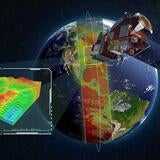
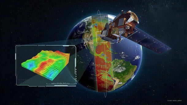
Today, CrIS is an essential component of the JPSS-2 and the first operational U.S. hyperspectral sounder. CrIS is planned to fly on all five JPSS satellites and was onboard Suomi-NPP and JPSS-1, which launched in 2011 and 2017.

Often credited as the lifeblood of medium-range, three-to-seven-day forecasts, CrIS provides detailed temperature and moisture data that dramatically improves the accuracy of weather models, especially for extreme weather forecasts. The instrument is an interferometer-based system collecting more than 2000 spectral channels. CrIS also scans a 2,200 kilometer swath width with 30 Earthscene views. Each view consists of nine fields of view (FOVs) with 14-kilometer diameter spots in a 3x3 array providing a highly detailed data set of the atmosphere around the globe.

Tornado Header

Our innovative weather solutions provide life-saving data that makes advanced weather forecasting and early warning possible.

The Future of Extreme Weather Forecasts

Extreme weather impacts nearly every American, and in 2021 the U.S. experienced 20 separate billion-dollar disasters. In fact, over the past five years the U.S. has experienced almost $750 billion dollars of damages from weather and climate disasters.[1] Using infrared sounder data improves severe weather forecasts, providing vital time to enact safety measures and save lives and protect property from the impacts of a rapidly changing environment.

CrIS is well suited to support NOAA weather forecasts including extreme weather events by measuring the key temperature and moisture parameters every 12 hours from low Earth orbit (LEO) enabling improved prediction of  storms, fires, and flooding. Adding a hyperspectral sounder on NOAA’s GeoXO constellation is the logical next step towards creating a more weather-ready and resilient nation, as a geostationary hyperspectral sounder will provide the low latency, rapid refresh data that is currently missing as there is currently no geosynchronous orbit (GEO) sounding capability over the U.S.

When it comes to rapidly forming convective storms such as tornadoes, an advanced hyperspectral sounding instrument from GEO can provide rapid refresh of the detailed moisture and winds information within the critical timeframe and precise location. In fact, implementation of the GeoXO Sounder will provide 20-times the number of observations over the  continental US to complement CrIS’ global data. 

The launch of CrIS on the JPSS-2 marks an extraordinary milestone in our partnership with NOAA and NASA and relentless pursuit to create a more weather-ready nation. This partnership continues to grow as we accelerate the development of next generation capabilities to further protect Americans and ultimately save lives. 

Questions? Contact us.

Address