L3Harris Technologies successfully completed the system Critical Design Review (CDR) of the next-generation imager for the National Oceanic and Atmospheric Administration’s (NOAA) Geostationary Extended Observations (GeoXO) program, which will deliver more detailed data to forecasters and provide more advance warning of severe weather. This development milestone validates the imager’s detailed design and signals its readiness for system-level production.
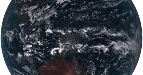
The L3Harris GeoXO Imager (GXI) is an advanced instrument that will measure infrared wavelengths, in addition to capturing data across the visible spectrum. This enhancement will provide detailed data regarding atmospheric conditions at higher resolution than today’s weather satellites. Sophisticated forecasting models rely on this data to monitor weather, ocean and environmental conditions and accurately predict severe storms.
“Building upon our 30-year legacy in delivering geostationary observation technology to NOAA, the GeoXO Imager will provide timely, accurate information that matters,” said Paul Wloszek, Vice President and General Manager, Spectral Systems, L3Harris. “These richer data sets will allow forecasters to identify severe weather earlier, which in turn can help local leaders alert the public and take informed steps to safeguard their communities and save lives.”
The GeoXO system is important for ensuring continued delivery of timely, detailed and accurate weather information for the entire Western Hemisphere, and is designed to enhance the capabilities of the GOES-R series of satellites in operation today. When it enters service in the early 2030s, GeoXO will deliver better short-term forecasting capabilities and provide even more advance warning of severe weather. GeoXO will also more precisely detect and monitor hazardous conditions such as wildfires, smoke, drought and flooding in order to support public warning systems.
The development of this mission-critical weather sensor technology is being undertaken as part of a contract with NASA, in support of NOAA. The GOES-R series of satellites includes L3Harris’ Advanced Baseline Imager, GOES-R Ground System and spacecraft propulsion systems.