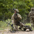
Confidence in his team is critical to mission success, as is his trust in the reliability of his equipment. Everyone needs to be situationally aware, from deputies on the ground to Tactical Flight Officers (TFO) who operate the L3Harris WESCAM MX™-10 EO/IR system from the cockpit. That's why every time Mark is airborne, he and his team look for ways to improve.
"Every time we go out, I'll have the guys working with the camera," says Mark, who's held various roles in Texas law enforcement for nearly four decades.
"Whether during live missions or after an event has taken place and we are conducting further surveillance and reconnaissance of surrounding areas, we will conduct simultaneous training using our imaging system. That means turning the camera on, locating specific landmarks, tracking vehicles or surveilling nearby environments. The more the team uses it, the better they'll be. Its use becomes second nature."
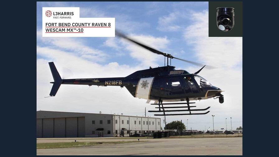
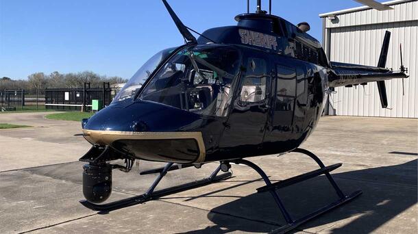
While the Fort Bend County Sheriff's employs 1971 and 1973 models of Bell's OH58A helicopter, each aircraft includes state-of-the-art technology, from navigation systems to electro-optical infrared cameras and sensors. Acquiring the aircraft through a military acquisition program in partnership with the National Guard, each helicopter was military green when they received them. New paint jobs and installation of the latest 2022 surveillance equipment, including L3Harris' WESCAM MX-10, quickly brought their air support division to the cutting edge of airborne law enforcement capability. While the whole system is assembled in L3Harris’ new facility in Hamilton, Ontario, Canada, the WESCAM MX-10 also includes integral infrared sensors manufactured by L3Harris engineers in Mason, Ohio, showcasing the collaboration between L3Harris teams that goes into each EO/IR sensor system.
"In aviation, you are constantly changing out parts, one at a time, making sure everything is working together. But soon enough, once you have good equipment, you're in great shape", says Mark. For Fort Bend, this includes having the best EO/IR imaging systems available for ALE agencies. Adaptable and versatile, the L3Harris WESCAM MX-10 is a smaller, capable and affordable commercial sensor system that incorporates field-proven technology, including fully active 4-axis stabilization. The multi-spectral sensors also provide imaging over multiple wavebands, ensuring both day and night imaging capability that provide a consistent image through a wide range of weather conditions.
"Along with the reliability, the clarity has helped a lot," says Mark, often operating at an altitude of 700-800 feet but sometimes rising to 1200-1300 feet to give his TFO more flexibility to find their target. A digital, high-definition and fully stabilized image takes out any guesswork and is capable of providing visual accuracy and precision at altitudes as high as 5000 feet. "It makes it much easier to determine what we're looking at. We can even tell if we see a person or squirrel in a tree. It's that accurate."
The Fort Bend County Sheriff Air Support Division uses its tactics and skills to assist in various missions within Fort Bend and many surrounding neighborhoods, communities and sister counties. Operations can include automobile and foot pursuits, officer assists and missing persons. Whatever the mission, Mark and his team can get in the air quickly and add a perspective that provides increased safety to their fellow officers and the public.
"In Fort Bend County, we often get calls for missing people. So any time there's a search, we use the WESCAM MX-10. Whether we're searching rooftops, looking at terraces at different heights or if we need to cover many areas quickly, we can do it. In Fort Bend, there's a lot of farmland, pastures and waterways – places ground units can't reach. In many instances, missing persons have found themselves in or around waterways. If the ground unit is having difficulty or they get word that someone has made their way to a pond, lake or river, we'll begin our airborne search using our thermal imaging."
Mark also lauded the WESCAM MX-10's thermal capabilities when searching for persons who wander away to vast fields and the speed at which they can effectively scan and search an area. As an airborne law enforcement team, Mark also comments on the essential role the WESCAM MX-10 plays in their mission effectiveness. "When it comes to finding suspects, the thermal display does more than we need it to do."
Before equipping their helicopters with WESCAM MX-Series imaging systems, Mark was aware of the industry-leading qualities their current imaging systems could not match. "I always listen to what others say and how they do things and I heard of the effectiveness of the WESCAM MX-Series units used by the Department of Public Safety. My sons, who are also police officers, told me that DPS always caught suspects and found people. The more we looked into it, the more we realized that L3Harris’ WESCAM MX-10 made the most sense for us. So we made the switch."
A case involving the handling and storage of narcotics proved how an air support division equipped with reliable and high-definition imaging technology could assist in reconnaissance and assessments of criminal hideouts. Following a lead to a potential narcotics stash house, Mark and his TFO soared up to 1500 feet and remained far enough away not to alert the suspects. "We can take a video recording of the property, take snapshots, and effectively assess with the camera; what's in the backyard? What's in the front? Where are the doors and windows? Then we can go back to the team with the footage and images and say, ok guys, here is where we're going to hit tomorrow morning."
The ability of Mark and his TFO to use imaging technology effectively as a team leads to successful missions. It allows officers to accomplish their objectives and come home safely at the end of their shifts. "We call it crew resource management. Especially in airborne law enforcement, taking the burden off one and equalizing it throughout the team is a big thing," says Mark.
The ability of the WESCAM MX-10 to fully integrate with the platform and third-party systems allows flight crews to take full advantage of the system. For example, while Mark is navigating and maintaining altitude and orbit, his TFO can take further directions from dispatch while also controlling the camera. "Working together with dual monitors and operating the systems like this allows us to manage any situation effectively and gives us a huge advantage."
All of this is possible with the L3Harris WESCAM MX-10, which provides Airborne Law Enforcement, like the Fort Bend County Sherriff, with a low-weight imaging system ideal for everyday low-altitude tactical surveillance and reconnaissance missions from both manned and unmanned airborne platforms.
See First. Act First.
Learn how you can bring the ultimate capability to your airborne law enforcement division at WESCAM MX™-Series | L3Harris™ Fast. Forward
[This article has been updated, original publish date: July 19, 2023]