
Geospatial Analytics

Unlocking Insights with Geospatial Analytics

Geospatial Analytics Overview

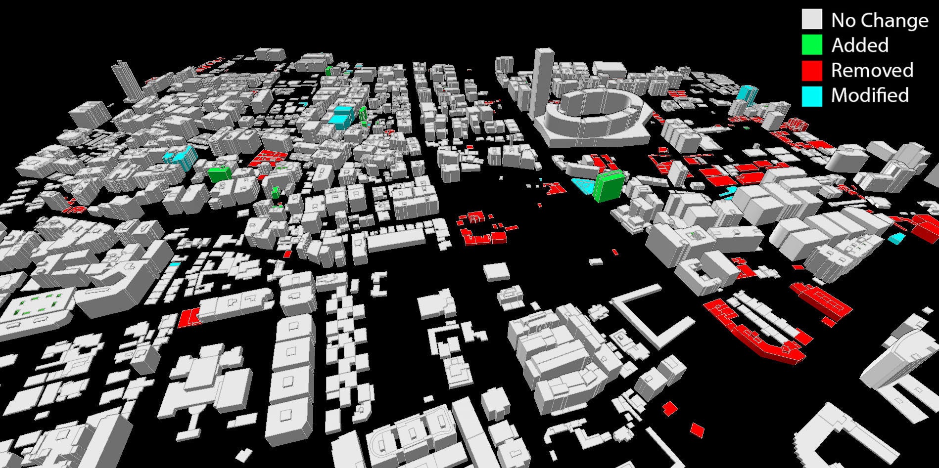
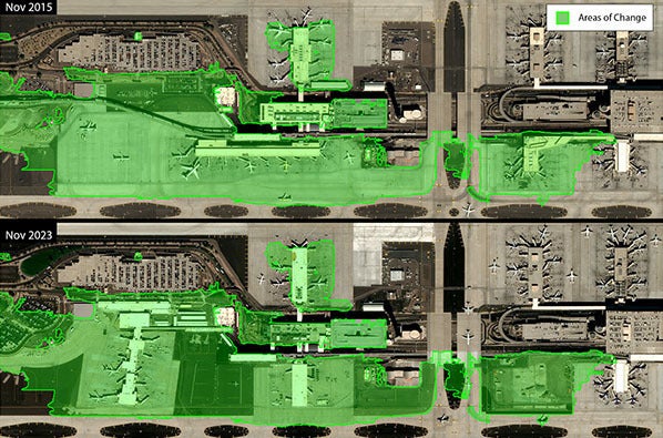
Harnessing the power of high-resolution aerial and satellite imagery, geospatial analytics offers a window into the dynamic processes shaping our world. By capturing sequential images, we gain a comprehensive understanding of spatial phenomena, ranging from burgeoning urban centers to the aftermath of ecological upheavals.

Advanced algorithms, coupled with machine learning techniques, sift through vast datasets to pinpoint patterns, trends and irregularities. This meticulous analysis converts raw visual data into strategic intelligence, empowering stakeholders to act with precision and foresight.

Advantages of Geospatial Analytics:

  • High Accuracy: Achieve meticulous identification of spatial changes with detailed vector and 3D models.
  • Timeliness: Conduct rapid analysis of recent data to deliver current and relevant information.
  • Comprehensive Coverage: Monitor expansive and inaccessible territories with ease.
  • Cost Efficiency: Minimize the necessity for labor-intensive field surveys and inspections.
  • Enhanced Decision Making: Gain invaluable insights for informed planning, resource management and risk assessment.

Request a Quote

Change Detection

Change Detection Overview

Unveil the hidden narratives of landscape evolution with Change Detection Analytics. Utilizing cutting-edge satellite imaging and analytical techniques, this tool is indispensable for urban development oversight, environmental impact assessments (or EIAs) and post-disaster evaluations.

Change Detection Analytics equip urban planners, environmentalists and emergency responders with the intelligence needed for tactical planning and resource distribution.

Elevate spatial analysis with 3D Change Detection, which provides an extraordinary level of detail and dimensionality. By comparing stereo imagery from different dates, our state-of-the-art algorithm constructs precise 3D models, enabling meticulous examination of structural developments and modifications.

REQUEST A QUOTE

3D Change Detection

Revolutionizing Earth observation, 2D Change Detection products offer a novel perspective on terrestrial transformations. Select two points in time, and our sophisticated algorithm will spotlight areas of notable change, delivering an accurate 2D vector shapefile for in-depth analysis.

REQUEST A QUOTE

2D Change Detection

For further exploration of geospatial analytics and how it can revolutionize your projects, please reach out to our team at geospatialdata@l3harris.com for more information.

Related News

Facility at night sky

Press release | 04. 07. 2026

US Space Force Selects L3Harris to Strengthen America’s Defense with Advanced Space Surveillance

L3Harris Technologies has received a $150 million contract from the U.S. Space Force’s Space Systems Command to sustain and modernize critical ground systems, which enable faster decision-making, earlier threat warning and sustained space superiority.

Facility at night sky

Press release | 04. 07. 2026

US Space Force Selects L3Harris to Strengthen America’s Defense with Advanced Space Surveillance

U.S. Space Force's Space Surveillance Telescope's primary mirror after having been recoated. Thumbnail image

Editorial | 02. 25. 2026

Keeping America’s Space Watchtower Sharp: US and Australia Work to Advance Critical Telescope Capacity

Artemis roll out

Editorial | 01. 30. 2026

Artemis II Wet Dress Rehearsal: Taking Things Into the Home Stretch

L3Harris Meadowlands system

Editorial | 12. 10. 2025

US Space Force Expands Offensive Space Programs Through L3Harris Foreign Sales

C3-class Solar Flare Erupts on Sept. 8, 2010. Photo credit: NASA/SDO. thumbnail image

Editorial | 12. 03. 2025

L3Harris Supports NOAA’s Million Mile Journey to Safeguard Earth from Solar Storms

Related Capabilities

Geospatial Data & Imagery Header

Geospatial Data & Imagery

Related Domains & Industries

Solutions that solve our customers' toughest challenges.
view all capabilities