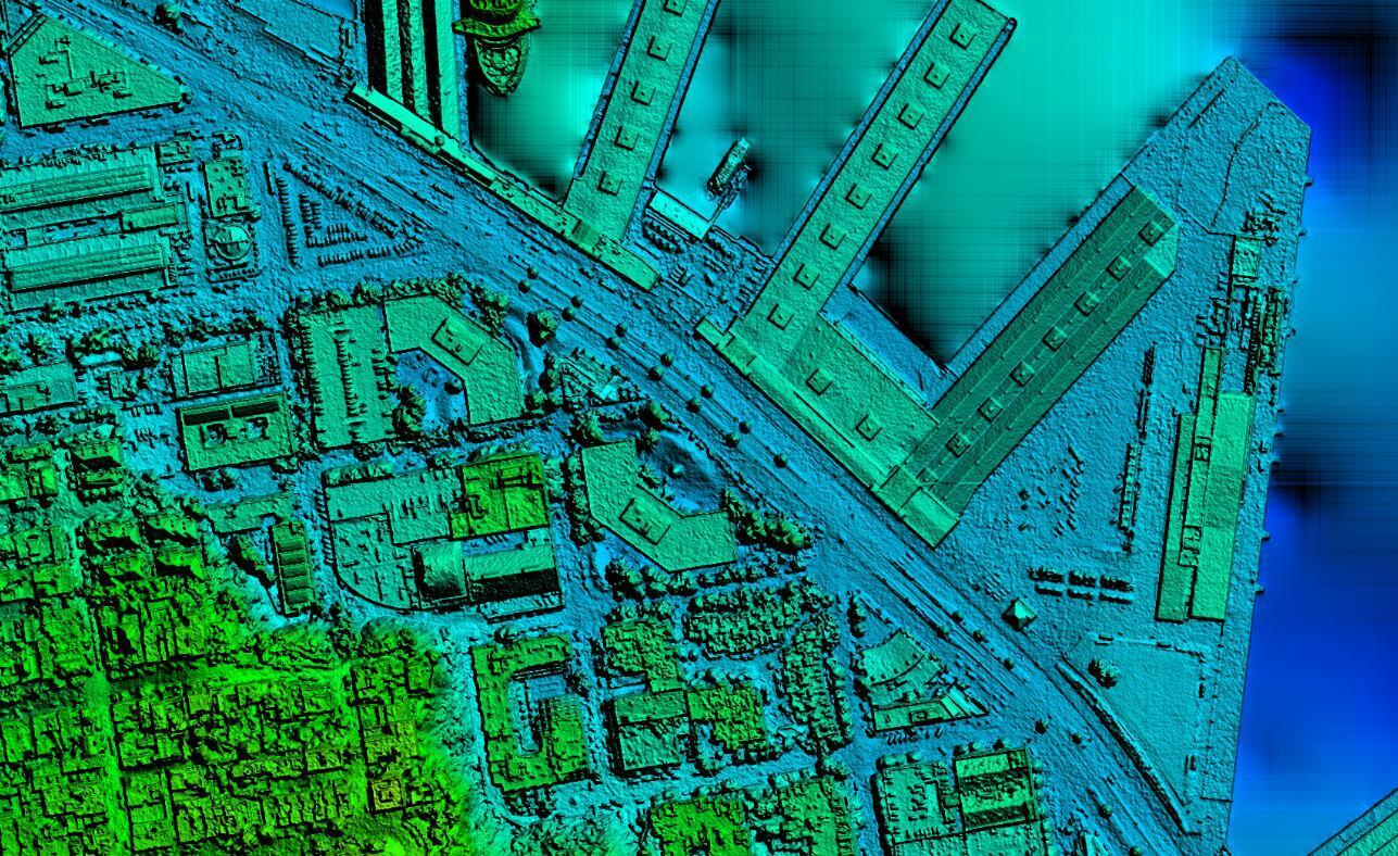
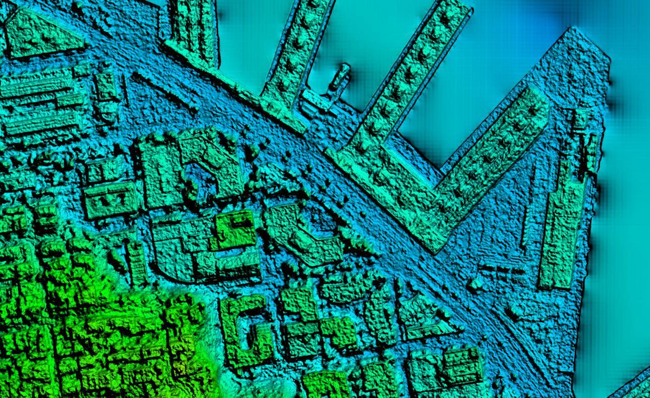
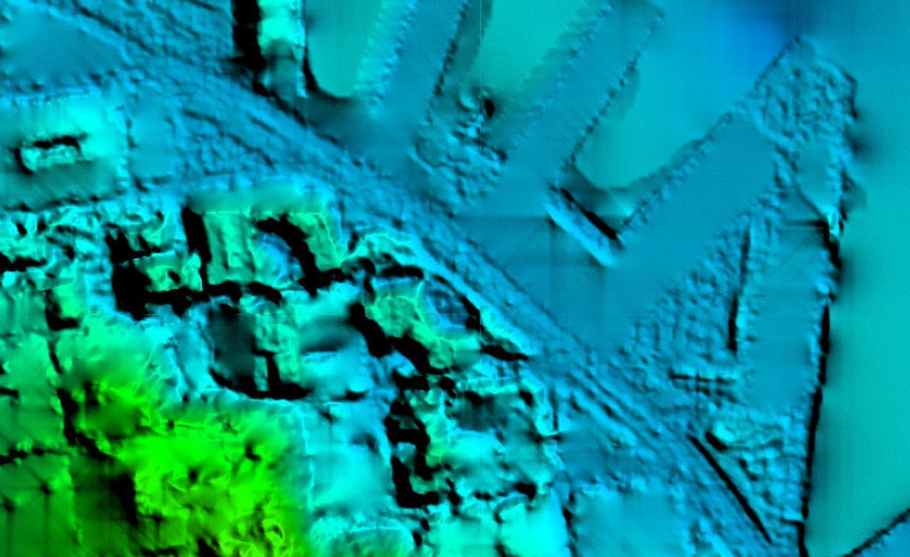
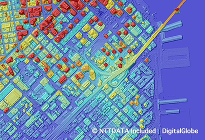
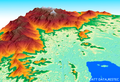
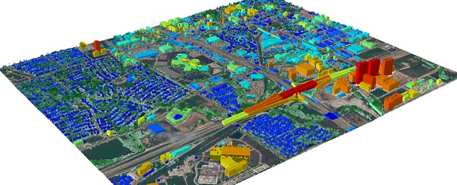
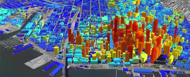
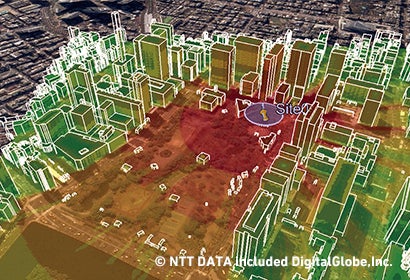
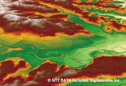
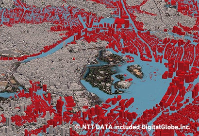
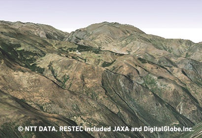
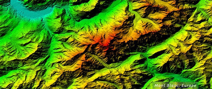
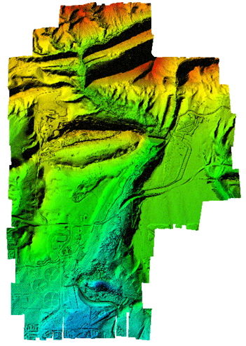
Elevation Data: Digital Elevation Models 

Elevation Data

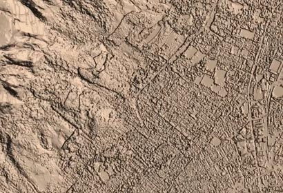
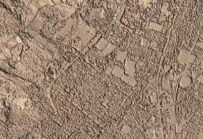
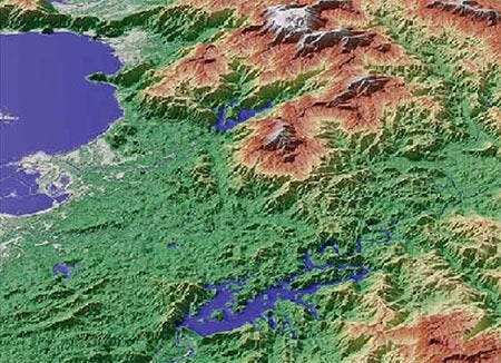
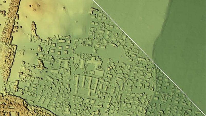
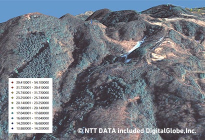
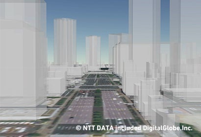
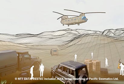
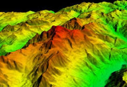
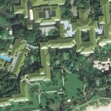
Render any area on Earth in meticulous detail with our wide range of custom Digital Elevation Models. L3Harris can use various data sources (satellite, aerial, and LiDAR) to automatically process and produce high-quality, high-resolution, and high-accuracy Digital Elevation Models over large areas. For decades, clients in industries such as visual simulation, mapping, engineering, and urban planning have relied on our domain expertise to help them get the most out of their data.  

Our Digital Surface Models (DSM) and Digital Terrain Models (DTM) are available at various resolutions - 0.5 meter to 90 meter. A DSM represents the Earth’s surface and includes vegetation and artificial objects, while a DTM represents the Earth’s surface without objects like vegetation and buildings. For areas with insufficient archive elevation coverage, our data experts can create custom elevation data applications and partner with top public and private vendors from around the globe to develop new datasets tailored to your unique needs.  


PlanetObserver logo

Vexcel Data Program logo

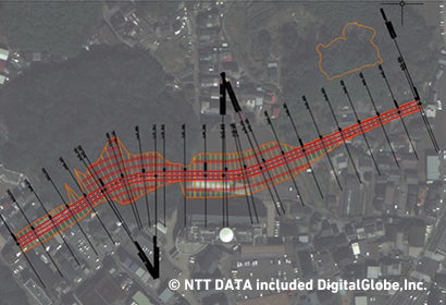
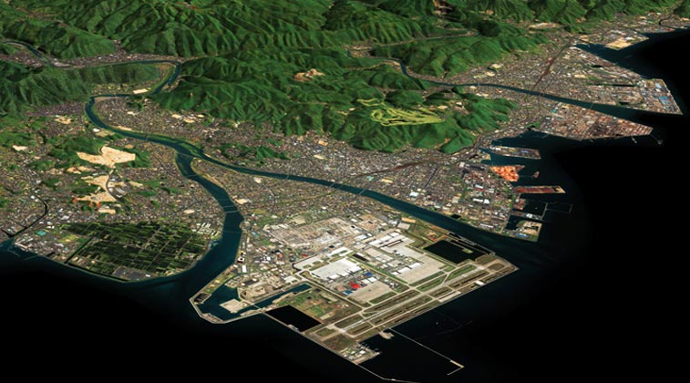
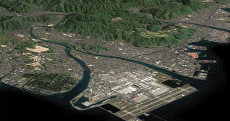
Finding the right image or data is rarely easy. Contact us if you need to learn more about the type of Digital Elevation Model your project requires or if a sensor doesn't cover your area of interest. Whether it's tasking satellite imaging technology to get it or mining our vast archive of datasets for context, L3Harris will deliver you the right imagery for your project.  


Request A Quote

“L3Harris’s ability to convert images into our distinctive coordinate system while maintaining integrity of photo has given us an additional source of survey verification” Kurtis Popkie, Westmoreland Mining

Airbus

Airbus Defence & Space's various elevation data options — including Digital Elevation Models — are uniquely suited for oil and gas terrain analysis, military activities, and the planning or updating of infrastructure networks. Airbus also offers more comprehensive elevation data options from optical stereo and SAR data, allowing users to gain actionable insights about any location on Earth, regardless of slope, location, light, or cloud conditions.

0.5 METER TO 5 METER DSM & DTM DATA

Highly Precise Altimetric Information

Do you need to map an area with limited vegetation and structures? What about areas with significant relief? No matter your needs, Airbus’s range of models provides accurate, on-demand elevation data in various conditions.

Elevation1 is ideally suited for any areas with minimum vegetation and buildings, while Elevation4 is designed to capture any area — urban or rural — with significant relief. Key Features Include: 

KEY FEATURES:

Elevation4

Elevation4

Elevation1

Elevation1

Request A Quote

Airbus Defense WorldDEM Neo Satellite Imagery

Airbus Defense & Space’s WorldDEM Neo™

WorldDEM Neo™ provides a global (pole-to-pole) dataset of unique worldwide elevation data of unrivalled quality and accuracy. The entire world's land surface has been updated with collections made by high-resolution sensors to render the entire planet accurately and consistently. A global data set of this resolution has not existed before now.


Resolution: 5 meter post spacing
Projection: UTM / Geographic
Datum: WGS 84
Format: GeoTIFF and others
Dates: 2017 - present
Coverage: Homogenous, seamless, pole-to-pole world coverage

Samples

  • DSM Marseille


Request A Quote

Vexcel Data Program

Get a clearer understanding of the earth’s surface and human-made objects with Vexcel Elevate, including Digital Surface Model (DSM) and Digital Terrain Model (DTM) data.

Vexcel’s advanced camera systems capture more than just a pretty picture; they collect the elevation data simultaneously, resulting in a pixel-to-pixel match between the aerial image and DSM/DTM data for more accurate calculations. Apply filters to perform slope or surface analyses, quickly identify and differentiate ground or elevated features, and create output with desired object classifications, such as mapping solar panels or identifying objects between specific height parameters.

The rise of 3D data in GIS planning and mapping platforms indicates the growing need to have a stronger context and deeper understanding of the world around us. Digital Surface Model (DSM), Digital Terrain Model (DTM), and Digital Elevation Model (DEM) products tell the story of the earth’s surface, from capturing both natural/built features of the environment (DSM) to just natural/bare earth features (DTM/DEM).

Vexcel Data Program Digital Surface Model imagery

Vexcel Digital Surface Model (DSM) imagery


Vexcel Data Program Urban Elevate DSM Data

Vexcel Urban Elevate Digital Surface Model (DSM) imagery


Vexcel Data Program Digital Surface Models imagery

Vexcel Data Program Wide Area Digital Surface Models (DSM) imagery


Request a Quote

Industries from Utilities to Transportation, Telecommunications to Government have recognized the value derived from DSM data. And since the quality of DSM products are measured by the accuracy of the elevation at each pixel, Vexcel’s aerial data supports highly precise DSM derived information.

Vexcel Data Program Urban Elevate DSM Data

Vexcel Urban Elevate DSM imagery


Request a Quote

Take out vegetation and built objects like trees and power lines with Digital Terrain Model data. Easily view height and elevation of the bare earth as well as natural features like rivers and ridge lines. DTM information can be paired with DSMs to derive information such as height in a given area. Other uses include soil mapping, flood or drainage modeling, land use studies and other geological applications.

Vexcel Data Program Digital Terrain Models imagery

Vexcel Wide Area DTM Data Imagery


Request a Quote

AW3D

The possibilities for 3D mapping are infinite — ranging from wireless planning, city planning, infrastructure management, disaster management, and environmental monitoring to applications in public health and academic research.

RESTEC has established a vast network of source data to create the AW3D elevation maps that digitally depict terrain, ground undulations, and the heights of trees and buildings worldwide in the highest resolution available.

AW3D Enhanced

AW3D logo
AW3D ENHANCED

AW3D Enhanced Digital Elevation Models are some of the world’s highest resolution and most accurate digital maps derived from satellite data. With spatial resolutions ranging from 0.5 meters to 1 and 2 meters, AW3D Enhanced products are ideal for any project that requires medium- to large-scale mapping geodata. They produce DTMs so detailed that users can easily discern slight variations in the height of trees and other natural features.  


Resolution: 0.5 meter/ 1 meter / 2 meter 
Format: GeoTIFF, DEM, others 

Sample data available upon request

  • Tokyo 50 cm DTM
  • Tokyo 50 cm DSM
  • Morrison, CO 50 cm DSM
  • Morrison, CO 50 cm DTM
     

Request A Quote

Elevation Data
AW3D logo

Composed of more than 3 million image stacks, the AW3D Standard is the world's best global Digital Elevation Model. It covers land around the Earth in resolutions ranging from 2.5 to 5 meters. This product family comprises high-quality optical satellite data — Japan Aerospace Exploration (JAXA) used the ALOS-PRISM tri-stereo sensor to capture the source imagery that fuels AW3D Standard Digital Elevation Models. The AW3D Standard was begun in February 2014 as part of the public‐private partnership project among JAXA, NTT Data, and Japan's Remote Sensing Technology Center.  

Resolution: 5m 
Vertical Accuracy: 5 meter RMSE / 7 meter CE90 
Format: GeoTIFF and others 
 

Sample data available upon request

  • Morrison, CO 2.5 m DSM
  • Morrison, CO 2.5 m DTM


Request A Quote

Accurate, low-cost, and expansive, the AW3D Telecom is the ideal 3D elevation dataset for simulating wireless signal propagation. Thanks to its high accuracy, it complies with most telecommunication operators' standards. It’s also compatible with signal propagation analyses, such as car-to-car communication in a self-driving system. L3Harris provides complete datasets optimized for these purposes, including height values acquired from high-resolution satellites and land usage classification based on sensors.  

Vector map data

Request A Quote

Vector Data of buildings

The AW3D Building 3D elevation dataset uses the latest satellite imagery to bring ground features such as buildings, vegetation, and overpasses to life. Both 2D footprint and height information of each building is provided as vector data, which can be bundled with other layers to create sophisticated Digital Elevation Models. This dataset is perfect for various simulation applications such as telecommunications, asset planning, and line-of-sight analysis.  


Request A Quote

AW3D App Telecommunication

Natural and artificial objects often interfere with the millimeter-spectrum waves 5G networks need to operate correctly. That's why our clients depend on the power of highly accurate 3D Digital Elevation Models when designing 5G networks. AW3D's cutting-edge technologies capture the level of detail required to build advanced datasets for meticulously planned 5G networks.

  • Geo data for radio network planning / RF geo data / 3D geo data for wireless / Geo data for 5G / Network planning
  • Line-of-sight analysis
  • IoT / Smart city planning / Connected society / MMTC
  • Autonomous driving / Autonomous vehicle / Self-driving / Vehicle-to-vehicle / Vehicle-to-infrastructure / V2V / V2X / eMBB
  • Smart manufacturing / Drone / Robot / Machine / URLLC / Smart construction / Smart hospital / Smart agriculture
  • Interactive experience by VR and AR / Real-time video streaming / Wearable technology
AW3D App Mapping

Having highly accurate and detailed 3D digital terrain maps can make the difference between success and failure when designing 5G networks, which use millimeter-spectrum waves that are vulnerable to interference from natural and artificial objects. AW3D’s cutting-edge technologies capture the level of detail required to build advanced datasets for meticulously planned 5G networks. Use cases include:

  • Large- to medium-scale mapping
  • Contour lines and feature extraction
  • Cadastral analysis
  • Change detection
  • Base map
  • Digital map reference
AW3D App Disaster

Re-imagine a better tomorrow by using superior terrain data and object information to precisely simulate natural disasters such as landslides, floods, and building failures. From contour maps to Digital Elevation Models, our satellite imagery allows users to do more than assess damage and devise recovery plans; it also helps them make the places we love more resilient against extreme weather. Uses in disaster mitigation include:

  • Disaster simulation (landslide, flood, building collapse)
  • Emergency response plan / Disaster recovery plan / Hazard identification
  • Detect disaster-affected areas
  • Landslide volume estimation
  • Disaster-ready facility management
AW3D App Construction

Streamline and optimize any construction project with accurate, high-resolution, ready-to-use datasets from AW3D. Based on satellite imagery, they're as precise as aerial surveys, rendering initial on-site surveys superfluous and helping users complete the preconstruction phase faster than ever. They also cover vast areas without worrying about flight restriction zones. AW3D datasets are compatible with GIS software and CAD platforms and enhance large infrastructure projects such as road and rail construction, city planning, green area management, and dam construction. Use cases include:

  • Geological surveys (topology, terrain, object count, land use)
  • Population estimations from building volume calculation
  • Infrastructure construction & land development (soil volume, 3D visualization, route planning)
  • Design simulation (wind/fluid simulation, sunlight simulation, line-of-sight propagation)
  • Approval processes (3D simulation of post-project conditions)
  • Year-to-year change tracking
AW3D App N Resources

AW3D provides accurate, detailed terrain site information faster, safer, and more affordably than on-site surveys. Renowned for its accuracy in both vertical and horizontal dimensions, AW3D is also compatible with non-visible bands such as shortwave infrared, making it the perfect choice to assist explorations for natural resources such as oil, gas, iron, gold, and more. Uses include:

  • Mining exploration
  • Exploration site selection
  • Exploration site management
  • Pipeline planning and management
  • Geothermal facility survey
  • Basin analysis
AW3D App Electricity

Surveying an expansive area before constructing or repairing a power grid can be costly and time-consuming. 

With AW3D terrain model datasets, users expedite the design phase by getting the accurate data they need quickly — ensuring they manage critical resources effectively and complete project goals ahead of schedule. These datasets drive success in dam construction, soil-volume calculation, and river slope analyses. Additional uses include:

  • Power facility management and maintenance
  • Power plant construction
  • Power line route planning
  • Initial design phase (hydroelectric power station)
  • Post-completion illustration
city vector graphic

Autonomous car systems — the future of transportation — depend on the power of high-accuracy 3D data, yet we've mapped less than 1 percent of the global road network with this advanced technology. That will change as self-driving cars become an everyday reality — and AW3D datasets will help render that future in precise detail.

Powered by AI, 3D mapping techniques, and advanced processing, AW3D datasets extract critical transportation information such as road lanes, line markings, slope information, and the height of nearby objects quickly and efficiently to help support the development of autonomous car systems. Use cases include:

  • Self-driving (autonomous car) system map creation
  • Map updating
  • Road line markings
  • Road elevation, slope calculation
  • Initial design phase (hydroelectric power station)
  • Post-completion illustration
AW3D defense image

AW3D offers high-resolution and highly accurate 2D and 3D geospatial data covering wide areas with a short turnaround making it useful in supporting critical and timely decision making on matters of national security.

  • Map creation/topographic mapping
  • Situation assessment
  • Logistic support
  • Flight control
  • Diffusion simulation
  • Image processing
  • Actionable intelligence

Hexagon Elevation Data

Hexagon collects two types of data suitable for creating elevation data: overlapping stereo aerial imagery and LiDAR data. The stereo imagery-derived elevation data, referred to as InfoCloud, has many advantages, including very high elevation point density, opening up applications such as vegetation and building mapping, line of sight analysis and realistic 3D imagery visualization. Elevation data options exist anywhere that Hexagon collects aerial imagery, which is much of North America and Western Europe. 

The LiDAR-derived data options deliver even greater vertical accuracy for the elevation data products. This LiDAR option is available in major cities that are covered by the Metro HD data offering.

The standard elevation data type from Hexagon’s nationwide coverage is the Digital Surface Model (DSM) which delivers all surface feature heights. 

PlanetObserver

PlanetObserver provides high-quality global elevation data, fully processed and ready for immediate integration. PlanetDEM, a global Digital Surface Model (DSM) at 30-meter resolution, offers consistent and gap-free coverage with improved terrain realism. Ideal for defense, aerospace, simulation, and GIS applications, PlanetObserver elevation data supports mission planning, 3D visualization, and analysis with reliable accuracy and seamless usability.

PlanetObserver vector map

PlanetDEM is a global Digital Surface Model (DSM) at 30-meter resolution, delivering consistent, gap-free elevation coverage with enhanced terrain realism. Fully processed and ready for immediate integration, PlanetDEM ensures seamless usability across a wide range of platforms and systems.

Ideal for defense, aerospace, simulation, and GIS applications, PlanetDEM supports mission planning, 3D terrain visualization, and spatial analysis with dependable accuracy. Developed by PlanetObserver with over 35 years of geospatial expertise, PlanetDEM provides the elevation foundation professionals need to build precise, high-performance solutions

PlanetDEM 30M Global Elevation, Mont Blanc, Europe imagery

Resolution: 30 meter grid spacing 
Vertical Accuracy: 7m 
Sources: AW3D, NASADEM 
Projection: Geographic 
Datum: WGS 84 
Format: DTED2
Delivery mode: FTP

Request A Quote

Elevation Data Services

Aerial Survey map

Remove the guesswork and invest in your most valuable resource with the best elevation data for your project — delivered and processed by experts.  

L3Harris provides comprehensive elevation data for local and worldwide coverage and creates customized models that help users predict, anticipate, prepare for, identify, and address any challenges they might face. Our expert photogrammetrists, programmers, and imagery scientists draw upon their vast experience and access to nearly all data types from top vendors to provide comprehensive solutions that remove project uncertainty so you can make swift decisions with confidence.

Digital Terrain Models

A Digital Terrain Model represents the earth’s surface without objects like vegetation and buildings. Small-footprint stereo paired with significant overlap automatically generates 3D mass point terrain data, which our data experts edit using triangulated stereo images. Key features include:

  • Highly accurate engineering-grade bare-Earth DTMs from aerial and drone imagery
  • Automated mass point generation and stereo-derived breaklines
  • Hydro enforcement and road flattening
  • Highly accurate contours derived from DTMs
  • High volume scalability using GRID processing computing power


Dense Digital Surface Models

A Digital Surface Model (DSM) represents the Earth’s surface and highlights vegetation and man-made objects. Key features include:

  • High-resolution DSM at one post per pixel
  • High-fidelity DSM with sharp edges
  • Smooth building and ground surfaces
  • Utilization of multiple sources such as pseudo stereo and true stereo imagery simultaneously
  • Hydro enforcement and road flattening
  • High volume scalability


Spatial Resolution of ElevationMap Scale EquivalentHorizontal Accuracy (CE90 – Circular Error with 90% Confidence)3D Mass Points
0.25 ft.1:600 (1” = 50’)1.5 ft.3D mass points, 1 – 10 ft. density, and terrain breaklines
0.5 ft.1:1200 (1” = 100’)1.0 ft.3D mass points, 5 – 15 ft. density, and terrain breaklines
1.0 ft.1:2400 (1” = 200’)2.0 ft.3D mass points, 10 – 25 ft. density, and terrain breaklines
1.5 ft.1:4800 (1” = 400’)2.5 ft. 


Satellite Survey image

3D Terrain Elevation

Drape TrueTerrain orthomosaic imagery over a digital elevation surface to create realistic 3D textured terrain you can visualize and analyze in real time.

  • Multiple supported industry-standard formats, including OpenFLT, OBJ, and more, are available.


Request A Quote

Terms & Conditions

  • Event Placeholder Banner

    Data & Imagery Products Policies

Related News

TerraColor NextGen satellite imagery map

Editorial | 08. 27. 2025

Large-Scale Impact: Global Geospatial Datasets in the Modern World

L3Harris Technologies’ geospatial data products team has played an integral part in developing global product lines in collaboration with our customers and partners.

TerraColor NextGen satellite imagery map

Editorial | 08. 27. 2025

Large-Scale Impact: Global Geospatial Datasets in the Modern World

L3Harris Christopher E. Kubasik speaks at a podium at a facility

Press release | 08. 21. 2025

L3Harris Expands Florida Facility to Support America’s Golden Dome

Group photo of Indiana Congressional delegation staff welcomed by L3Harris staff at L3Harris' Fort Wayne manufacturing facility

Editorial | 07. 31. 2025

Officials Tour L3Harris Indiana Facility Recently Expanded to Support America’s Golden Dome

Vera C. Rubin Observatory LSST First Imagery shows the Virgo Cluster

Editorial | 06. 23. 2025

NSF-DOE Rubin Observatory Unveils First Images with Support from Mirror built by L3Harris

An image of Valencia, Spain, in the OneAtlas Living Library

Editorial | 04. 29. 2025

On-Demand Imagery: Enhancing Monitoring and Analysis with Advanced Streaming Platforms

Related Domains & Industries

Solutions that solve our customers' toughest challenges.
view all capabilities