Visualize the Earth’s surface in the harshest conditions with Synthetic Aperture Radar (SAR), an innovative solution for collecting and analyzing data in adverse weather. SAR allows you to see through rain, smoke, clouds and even darkness to obtain high-resolution imagery at critical moments. Don’t be at the mercy of the elements; stay ahead of the curve with the power of Synthetic Aperture Radar. L3Harris, a leading provider of SAR solutions, provides a range of options to suit user requirements.

How Synthetic Aperture Radar Works
Synthetic Aperture Radar is an active, 24-hour technique for collecting data in any weather, at any time.
This alternative to traditional remote sensing doesn’t rely on sunlight to capture detailed images of a project site. Instead, Synthetic Aperture Radar illuminates the ground by emitting energy waves and measuring the rate of return to detect and map features obscured by obstacles like cloud cover. While optical imagery resembles a static photograph, SAR is reactive, responding to land surface characteristics such as moisture and structures.
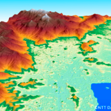
This makes SAR the ideal option for collecting data in areas with persistent cloudcover, such as small oceanic islands, rainforests and other areas in the global cloud belt. It also has countless applications in the government, military and commercial sectors. Whether surveilling a border to enhance national security, obtaining real-time imagery for a military mission, or monitoring a major infrastructure project to prevent delays, Synthetic Aperture Radar helps users make better strategic decisions and maximize resources.
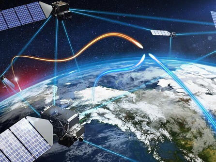
Sensors & Satellites
SAR responds to land surface characteristics such as moisture and structures which is different than its optical cousins who collect imagery interpreted more like a photograph. This type of data collection is ideal for areas where cloud cover is a perpetual condition, such as small oceanic islands, rainforests, or other areas located in the global cloud belt.
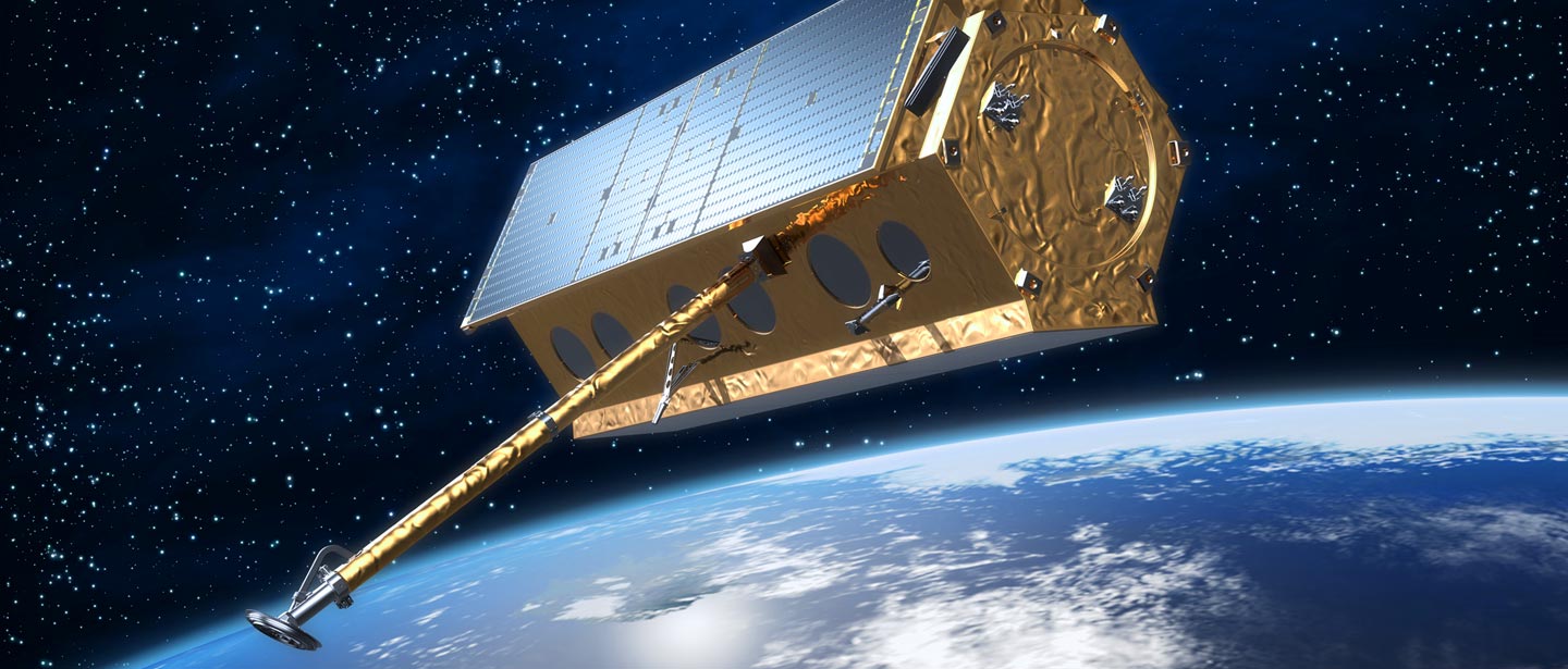
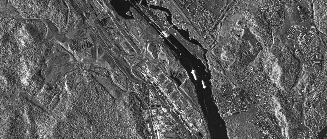
TerraSAR-X from Airbus Defence and Space
Cloud cover and lighting conditions won't deter the TerraSAR-X 9, two high-resolution radar satellites that capture data about the Earth's surface even under unfavorable weather conditions. These satellites gather data in the middle of the night and through the densest cloud cover – obtaining data ideal for movement tracking, ground subsidence, watercraft and construction monitoring, and any other form of physical change detection. Users depend on TerraSAR-X to track details as small as vehicles or aircraft. These data sets also enhance land use mapping and other classification projections.
Airbus Defence and Space Services offers an extensive portfolio of high-quality TerraSAR-X data products of different modes and processing levels to suit a wide variety of needs. TerraSAR-X was designed with global commercial users in mind and is optimized to deliver data for a wide range of sophisticated applications.
Resolution: Down to 25 cm
Band: X-Band Radar
Projection: UTM or Lat/Long
Datum: WGS 84
Dates: 2007 — present
Samples available upon request
Hi-Res Spotlight (up to 1-m resolution — 330 MB
ScanSAR (up to 18-m resolution) — 243 MB
Spotlight (up to 2-m resolution) — 196 MB
Staring Spotlight (up to 25-cm resolution) — 437 MB
Wide ScanSAR (up to 40-m resolution) — 353 MB
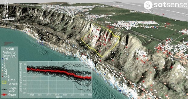
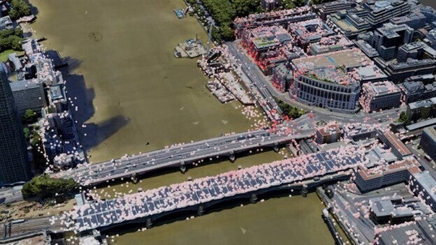
SATSENSE: UNLOCK GROUND MOTION INSIGHTS WITH RADAR IMAGERY
From tectonic activity to volcanic eruptions and extreme weather events, something is always changing the Earth’s surface. SatSense’s Interferometric Synthetic Aperture Radar (InSAR) allows users to easily detect, measure and monitor these developments.
InSAR measures ground movement from space down to the millimeter. Using satellite-based radar, InSAR detects ground movement while continuously monitoring infrastructure assets such as mines and transport and utility networks, including road, rail and utility pipelines. Users can precisely map and monitor entire cities and countries remotely with frequent, real-time updates.
InSAR’s processing algorithms are based on decades of research at the University of Leeds. SatSense uses the latest advances in artificial intelligence and machine learning to assess and monitor ground movement and structural stability and then determines which critical assets have the highest risk of failure. SatSense’s vast archive of historical analysis goes back to the 1990s, which helps users identify issues and optimize ground-based monitoring deployments. Ongoing monitoring enhances project-site understanding of a project site, limiting the need for boots-on-the-ground inspections while saving precious time and money.
L3Harris partners with SatSense to offer InSAR data monitoring as part of a robust suite of remote sensing solutions. Clear project views are available anytime and from anywhere using the same Synthetic Aperture Radar trusted by national rail operators, prominent utility companies and leading engineering firms from around the globe.
KOMPSAT-5
Operational since 2014, KOMPSAT-5 is the first South Korean satellite designed with an X-Band Synthetic Aperture Radar payload. It operates at dawn-to-dusk orbit between an altitude of 500 and 600 kilometers and can work in all weather and lighting conditions. The primary function of KOMPSAT-5 is to deliver high-resolution SAR images of 1-meter resolution, though it can also capture data covering larger areas at 3-meter and 20-meter resolutions. It's especially effective at going where optical sensors can't, obtaining data in regions affected by cloud cover or from sites at very high altitudes.
KOMPSAT-5
Resolution: 1 m, 3 m, and 20 m
Band: X-band
Projection: UTM, Lat/Long, State Plane
Datum: NAD 83, WGS 84
Dates: 2013 to present

Related News
Press release | 07. 13. 2026
US Space Force Selects L3Harris to Provide Advanced Tracking Satellites for America’s Missile Defense
L3Harris Technologies has received a contract from the U.S. Space Force’s Space Development Agency (SDA) to produce 18 Accelerated Missile Defense Tranche 3 (AMDT3) satellites to support the Golden Dome for America’s space-based capabilities.